

26 August 2025
Introducing infrADAC CAD and infrADAC Map:
Modern Tools for ADAC XML Management

The management of ADAC XML data has long been a challenge for councils, utilities, and consultants. Existing tools often rely on outdated software or fragmented processes that create inefficiencies and increase the risk of non-compliant submissions. To address these challenges, Galaxy Pixel Studios has released infrADAC CAD and infrADAC Map, two purpose-built applications designed to modernise the way organisations create, validate, and work with ADAC XML.
infrADAC CAD: Direct ADAC XML Integration within AutoCAD
infrADAC CAD operates entirely inside AutoCAD, enabling engineers to manage ADAC XML without leaving their design environment.
The software provides a direct connection between CAD drawings and ADAC XML submissions.
Key capabilities include:
-
Work with ADAC XML directly in AutoCAD : Import, edit, and generate ADAC XML files from within the drawing environment, removing the need for external tools.
-
Structured attributes from the ADAC Data Dictionary : Asset and project properties are applied consistently and remain aligned with the submission requirements.
-
Submission generation and validation : Every ADAC XML submission is automatically validated against the schema. A detailed audit report highlights errors and warnings, allowing issues to be resolved before submission.
-
Asset and profile control : Councils and utilities often have unique requirements. infrADAC CAD allows profiles to be configured so that project data matches the specific standards in place.
-
Support for supplementary assets : Create and manage supplementary assets, control their visual appearance inside AutoCAD, and attach supporting documentation such as images or PDFs for complete project records.
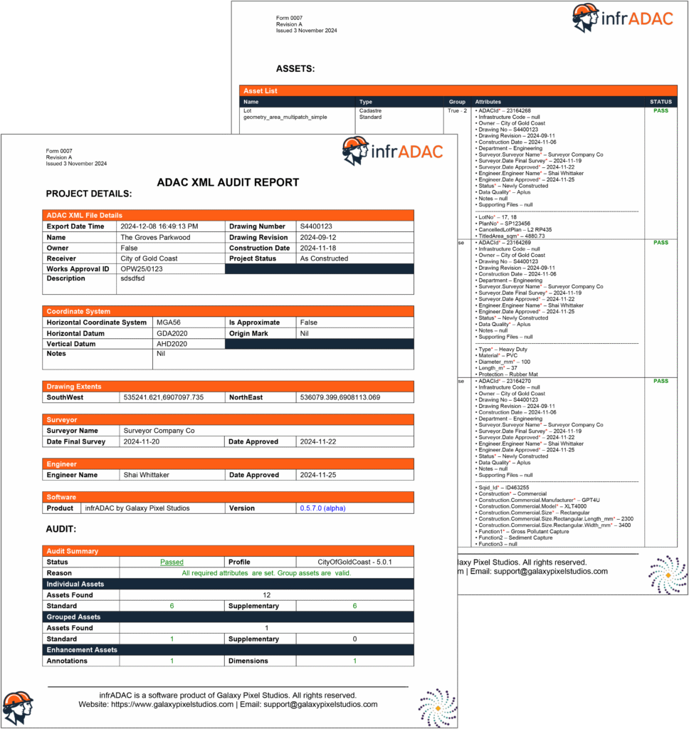
By unifying CAD design with ADAC XML compliance, infrADAC CAD ensures engineers can deliver accurate and reliable submissions that meet the requirements of approving authorities.
infrADAC Map: Browser-Based ADAC XML Management
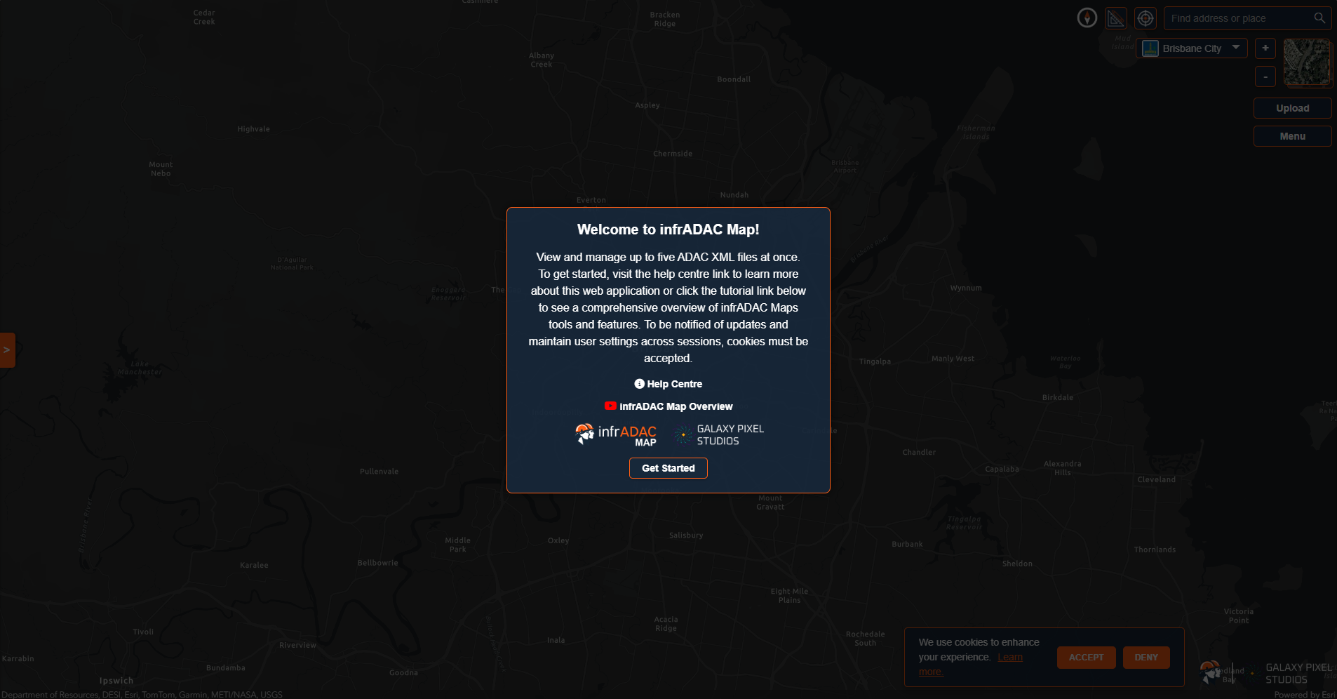
infrADAC Map is a browser-based application that makes it possible to visualise and validate ADAC XML datasets in real time without the need for installation or licensing. Its purpose is to make data review and assessment more accessible for both submitters and assessing authorities. Features include:
-
Load and view multiple ADAC XML files: Work with up to five files at once, switching between datasets for comparison or review.
-
Council and utility information: View LGA and utility regions on the map and access details such as supported ADAC versions, participating authorities, and links to official information.
-
Measurement and validation tools: Measure distances and areas directly on the map, confirm geometry accuracy, and validate against the ADAC schema to detect issues such as duplicate identifiers or incorrect coordinate systems.
-
Display preferences and labels: Save interface themes, basemap choices, and label settings for consistent use between sessions. Label visibility is automatically managed to keep the map clear at different zoom levels.
-
Supporting documents: Attach and review files linked to ADAC XML submissions, enabling complete context during quality checks.
With nothing to install and no costs for use, infrADAC Map provides an efficient and reliable way to assess and work with ADAC XML data across projects.
Working Together: Streamlining ADAC XML Workflows
infrADAC CAD and infrADAC Map are designed to complement one another. CAD users can create and validate submissions directly within AutoCAD, while assessment teams can open the same data in infrADAC Map for review. This combination creates a seamless workflow where datasets move smoothly from design to submission to approval.
For councils and utilities, the ability to validate and audit submissions before they are received reduces the administrative burden and increases confidence in the quality of delivered data. For consultants and designers, the tools provide assurance that their work complies with the ADAC standard before it reaches the authority.
Working Together: Streamlining ADAC XML Workflows
The release of infrADAC CAD and infrADAC Map marks a step forward in the modernisation of ADAC XML processes. Both tools are designed to reduce inefficiency, improve compliance, and make it easier for organisations to adopt and enforce the ADAC standard.
Organisations that are ready to streamline their ADAC XML workflows can now access a practical set of tools that combine technical precision with ease of use. With infrADAC CAD and infrADAC Map, the management of ADAC data is no longer tied to outdated software or manual validation. Instead, the process becomes integrated, verifiable, and efficient.